Digital Site Selection: Moving from Paper Maps to GIS Platforms.
Digital site selection replaces paper maps with GIS platforms, allowing investors to analyze infrastructure, logistics, and labor data to identify optimal factory locations and reduce investment risks.
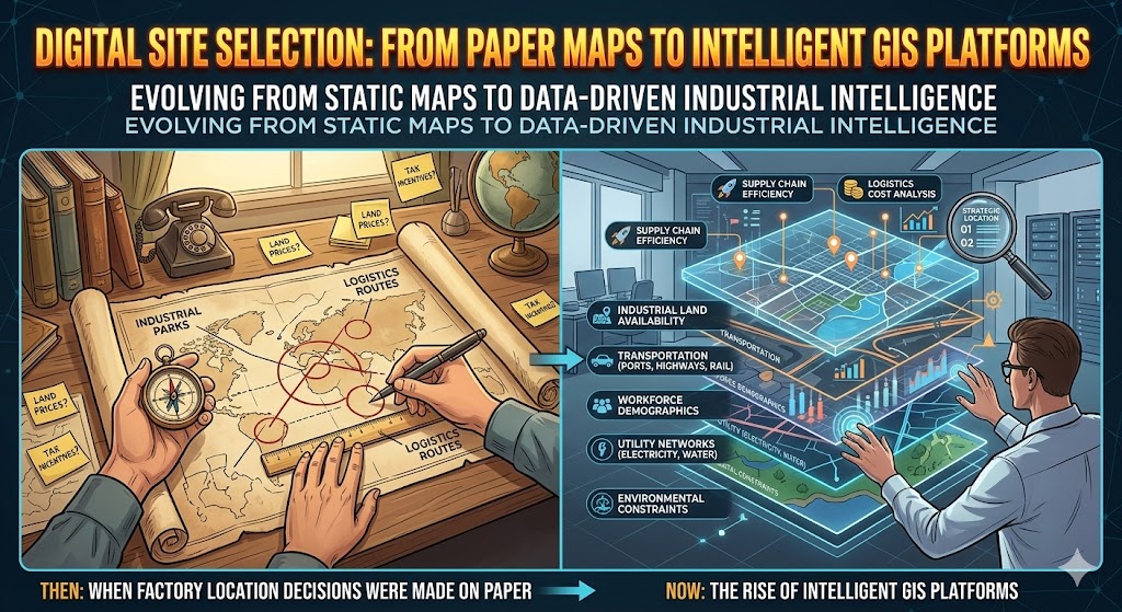
Digital Site Selection: From Paper Maps to Intelligent GIS Platforms
1. When Factory Location Decisions Were Made on Paper
Not long ago, industrial site selection relied heavily on static information. Investors evaluated locations using paper maps, fragmented reports, and basic statistics about land prices or tax incentives. Decisions were often shaped by local brokers, personal networks, or government recommendations rather than comprehensive data analysis.
This approach worked when manufacturing supply chains were simpler. However, today’s industrial ecosystem is far more complex. Modern factories must operate within global logistics networks, energy systems, labor markets, and environmental regulations. A paper map can no longer capture this level of complexity.
As a result, industrial investors are shifting toward digital site selection tools powered by Geographic Information Systems (GIS).
2. The Rise of GIS in Industrial Investment
GIS platforms transform traditional maps into interactive, data-rich decision tools. Instead of viewing a location as a static point on a map, investors can analyze multiple layers of information simultaneously.
These layers typically include:
- Industrial park locations and land availability
- Transportation infrastructure such as ports, highways, and railways
- Workforce distribution and demographic trends
- Utility networks including electricity and water supply
- Environmental constraints and zoning regulations
By overlaying these datasets, investors gain a comprehensive spatial understanding of industrial regions, enabling more informed investment decisions.
3. Why Digital Mapping Improves Investment Accuracy
Digital site selection significantly reduces uncertainty. Traditional methods often overlook hidden constraints—such as limited energy capacity, congested logistics routes, or labor shortages in surrounding regions.
GIS platforms help identify these risks early. For example, an industrial park may appear attractive based on rental prices alone, but spatial analysis might reveal that it lies over 120 kilometers from the nearest deep-sea port, increasing logistics costs for export-oriented manufacturers.
By visualizing such factors before committing capital, companies can avoid costly mistakes and optimize long-term operations.
4. Integrating Infrastructure and Supply Chain Data
One of the most powerful features of digital site selection is the ability to analyze supply chain connectivity. Modern manufacturing relies on efficient movement of raw materials, components, and finished products.
- GIS platforms allow investors to evaluate:
- Distance to suppliers and logistics hubs
- Access to highways and international ports
- Regional industrial clusters and supporting industries
This spatial insight helps companies position factories within strategic industrial ecosystems, improving supply chain efficiency and reducing transportation costs.
5. Faster Decisions in a Competitive Investment Environment
In a highly competitive investment environment, speed matters. Industrial land in strategic regions can become unavailable quickly as global manufacturers compete for the same locations.
Digital platforms accelerate decision-making by allowing investors to analyze hundreds of potential sites in minutes rather than weeks of manual research and site visits.
Instead of spending months gathering fragmented information, companies can immediately compare regions based on standardized data and geographic visualization.
6. The Future: From Maps to Industrial Intelligence
Digital site selection is only the first step toward a broader transformation in industrial investment. GIS platforms are increasingly integrated with big data, artificial intelligence, and predictive analytics, enabling investors to forecast industrial development trends rather than simply analyzing current conditions.
Future platforms may help investors anticipate:
- Industrial land price trends
- Emerging logistics corridors
- Workforce migration patterns
- Infrastructure expansion plans
In this way, digital mapping evolves into a full industrial intelligence system that supports long-term strategic planning.
7. Conclusion
The shift from paper maps to GIS platforms represents a fundamental change in how industrial investments are planned. Digital site selection provides a clearer, data-driven understanding of industrial geography, allowing investors to minimize risks and maximize operational efficiency.
In an era where manufacturing competitiveness depends on logistics, infrastructure, and regional ecosystems, intelligent mapping tools are becoming essential. Companies that adopt digital site selection early will gain a decisive advantage in the global race for industrial investment.
(1).png)